Don’t miss this glimpse into the world of endangered bighorn sheep
Ringed by mountains soaring dramatically from the desert floor, Palm Desert is a hiker’s paradise. Trails traverse across rocky hillsides and climb up ridgelines to higher elevations, affording panoramic views of the Coachella Valley.
Most of the area’s hiking trails are open year-round for hardy hikers or early birds. A select few have seasonal closures, however, and reopen each year on October 1. Well-timed to take advantage of cooler fall temperatures, the opening of these trails feels like the symbolic opening of hiking season in Palm Desert, as well.
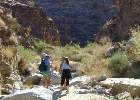
 The Eisenhower Peak Loop Trail is a popular destination with locals who appreciate its mix of expansive valley views from its ridgetop leg, and the “get away from it all” aspect of its canyon side. Located at The Living Desert Zoo & Gardens, the Eisenhower Peak Loop Trail offers a legitimate workout with 700 feet of elevation gain, but since that gain is stretched out over five miles, it never feels too exhausting. The canyon leg is deceptively harder than it looks, with knee-high rocks to navigate around or over. While many maps and conventional wisdom say to head out first toward the canyon segment of the loop, you may want to walk the trail in a clockwise direction, which leads you up the ridge and down the canyon. While your legs may be a bit more tired later in the hike, at least you’re not facing those rocks while going uphill.
Whichever way you tackle this trail, plan to make a day of it and visit The Living Desert after your hike. The trail can only be accessed through the Zoo, which requires a paid admission. For more on visiting The Living Desert, visit their website.
The other two trails which open each year on October 1, Carrizo Canyon Trail and Dead Indian Canyon, offer up a remarkably different viewpoint than the Eisenhower Loop Trail. Rather than climbing uphill, they meander into two secluded canyons marked by deep rock walls, native fan palm oases, dry waterfalls, and boulder fields. Here, the panoramic views found elsewhere are exchanged for a close-up trailside view of dramatic desert plants and wildlife.
The trails enter into the habitat of the Peninsular Bighorn Sheep, listed as endangered in 1998. One of the steps taken to protect this population was to close trails during both the spring lambing season and the summer season when it is critical that the sheep be able to access their water sources.
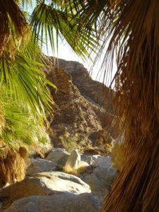
Dead Indian Canyon is a stunning canyon with colorful rock walls. The big draw here has long been the oasis featuring a couple dozen native fan palm trees, along with all the birds and wildlife that are drawn to this desert refuge. The trail is initially flat and easy, and particularly well suited for everyone from small children to more seasoned hikers. Reaching the oasis itself, however, is considerably more difficult and involves picking your own route and scrambling over and around boulders. If you feel like you’re prepared for the terrain, give it a go. If not, enjoy the view of the oasis from a distance. Watch and listen for bighorn sheep on the canyon walls early in the morning and at dusk as they head to the oasis for water.
Carrizo Canyon provides a unique desert canyon ambience and yet another possibility of spotting bighorn sheep. The trail goes up a sandy wash for a short distance before 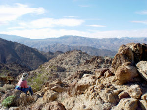 entering the mouth of the canyon, which grows more dramatic the further you travel. The canyon walls are accentuated by rock layers that have been twisted into odd patterns, and lend themselves to great photos. After climbing through a small boulder outcropping, you will eventually reach an area where the canyon branches off in two directions. The right branch heads to seasonal waterfalls with near-vertical faces, which should only be attempted by experienced hikers. The branch straight ahead continues uphill through a dry creek bed, eventually hooks back around to the right, and looks down on those dry waterfalls that you passed earlier. The end of the trail also offers a narrow keyhole view out to the valley beyond.
All of these trails fall into the moderate category and can be hiked by most hikers in good physical condition who are prepared for the combination of sandy and rocky terrain. The two biggest safety concerns to remember on these trails are the perils of too little or too much water. The most serious issue any hiker on any trail in the desert faces is dehydration, so it is suggested that you carry two liters of water per person.
Secondly, while Palm Desert is blessed with excellent weather, smart hikers always keep an eye on the sky. Do not venture into any canyon trail if it is raining, threatening to rain, or appears to be raining in upper elevation areas of the same watershed. Flash flooding is always a possibility under these conditions.
Bighorn sheep see all canines as predators and seeing one even from a distance will cause unnecessary stress for this endangered species. All dogs, regardless of their size or breed, are prohibited on these trails at all times.
Driving and Trailhead Directions:
Eisenhower Peak Loop Trail: Enter through The Living Desert, 47900 Portola Avenue, Palm Desert.
Carrizo Canyon and Indian Canyon: Head south on Highway 74, approximately 4 miles from Highway 111. Park at the Art Smith Trailhead parking lot on the west side of Highway 74, just past and across the street from the Santa Rosa-San Jacinto Mountains National Monument Visitor Center.
From the parking lot, the fence closing off Carrizo Canyon is readily visible, and the gate is a short distance from the southwest corner of the lot. Reaching Dead Indian Canyon involves walking north from the parking lot and following along the trail that hugs the ridgeline (not the trail that parallels the earthen berm). Eventually you will see the fencing that stretches across the canyon. Follow the trail to and through the gate.